
Photo: Johan Jönberger, SGU
Gravity measurements
By measuring Earth’s gravity field, we are able to map variations in the mass distribution of Earth’s crust. These variations are due to differences in the composition of the bedrock.
Gravity data is primarily used in bedrock mapping. The data can also be used for locating major aquifers. Other areas where gravity data is useful are in conjunction with exploration for ores, in various geodetic applications, for navigation and positioning purposes, deployment of strain gauges, and for calibrating precision balances.
The Geological Survey of Sweden (SGU) initiated systematical gravity measurements in the late 1950s in conjunction with the documentation of iron ores in northern Sweden. The regional, nationwide measurements were started in the middle of the 1960s, serving primarily as support for SGU’s bedrock mapping activities.
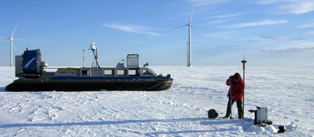
The measurements are carried out at the ground surface and mainly along roads since cars are primarily used for transportation. Snowmobiles or helicopters are used in areas with sparse road coverage. Measurements can also be carried out on the ice of frozen lakes or sea during the winter. The gravity measurements in the Gulf of Bothnia and the Bothnian Sea were carried out on the ice, mainly in the 1970s and parts of the 1980s. In the late 1990s, parts of the Bothnian Sea and a few sections of the Baltic Sea, Kattegat and Skagerrak were measured from ships. In 1999, the Baltic Sea, the Gulf of Finland, and the lakes Vänern and Vättern were measured from aircrafts. The measurements on the ice were carried out in collaboration with the Swedish National Land Survey and the Finnish Geodetic Institute. During the measurements from ships and aircrafts, SGU collaborated with the Swedish National Land Survey, the Finnish Geodetic Institute, Danish National Survey and Cadastre, the Norwegian Mapping Authority, the University of Bergen, and the geodetic institutions in Estonia, Latvia and Lithuania.
The aim is to acquire one measurement every 1–1.5 km when conducting regional gravity surveys. This is increased to about one measurement every 100 m in more targeted surveys.
When performing regional measurements, SGU aims at keeping a distance of 1–1.5 km between the measurement points. This is increased to about one measurement every 100 m in more targeted surveys. The measurements made by the Swedish National Land Survey, most of which are present in the SGU database, have a distance of 5 km between the measurement points.
The magnitude of the gravity value depends on the latitude, elevation above sea level (the geoid), geology, isostasy, the earth tide caused by the moon and sun’s gravitation, as well as the topography. Geophysicists and geologists are interested in the part of the gravity value that is affected by the mass distribution of Earth's crust, i.e. the geology. The gravity value is therefore reduced by these other factors in order to obtain only those gravity deviations which are related to the geology. These deviations are called terrain corrected Bouguer anomalies, which illustrate the mass distribution (density variation) of the subsurface down to great depths in Earth’s crust.
Last reviewed 2021-03-18