Go to main content
logotyp
  • Listen
  • In Swedish
  • Contact
SGU Start
Användarstöd för geologiska frågor Kartvisare GeoLagret Bergsstaten Geopraktisk ITP308 Mineraljakten
Menu Search
  • Start
  • Products and services
    • Geological data
    • Maps
    • Publications
    • SGU´s Survey Vessels
    • Assignment activity
    • Books and brochures
    • Customer services
  • Groundwater
    • Groundwater and the Swedish Water Framework Directive implementation
    • Good Quality Groundwater
    • Geological information for groundwater management
  • Mineral resources
    • Geological information for mineral exploration
    • Mineral statistics
    • Swedish mines
    • Metal and mineral recovery
    • Mines and environmental impact
    • Critical and strategic raw materials
    • Industrial minerals
    • Conflict minerals
    • Legislation
    • Geophysical mapping
    • Geochemical mapping
    • Bedrock mapping
  • Physical planning
    • Planning and land use
    • Rock materials for construction
    • Sea and coast
    • Hazards
    • Natural values
    • Contaminated areas
    • Energy
  • Geology of Sweden
    • Rocks
    • Minerals
    • Quaternary geology
    • Swedish geosites
    • BetterGeo – Minecraft with more geology
    • Geological names in Sweden
  • About SGU
    • Tasks and activities
    • News
    • Press and media
    • Organisation
    • Contact SGU
    • About the site
  • Contact
  • In Swedish
  • Start
  • Products and services
  • Maps
  • Map viewers
  • Groundwater map viewers

Subpages

  • Geological data
  • Maps
    • Map viewers
      • Bedrock map viewers
      • Geochemistry map viewers
      • Groundwater map viewers
        • Wells
        • Groundwater reservoirs
        • Springs
      • Quaternary map viewers
  • Publications
  • SGU´s Survey Vessels
  • Assignment activity
  • Books and brochures
  • Customer services

Groundwater map viewers

Here you will find SGU's map viewer with information about Sweden's groundwater resources. For example, you can find data on wells and test stations to monitor changes in groundwater levels and groundwater chemistry. For a complete collection please visit the Swedish map viewer.

  • Picture of map viewer Wells.

    Wells

    In the map viewer "Wells" there is information about the location of individual wells. There is also information about depth, soil depth, feed pipe length, dimensions, water capacity, water levels and the function of the well.

  • Groundwater reservoirs

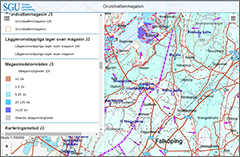
    The map viewer "Groundwater Reservoir" contains information about the distribution and abstraction possibilities of larger groundwater reservoirs. There is also information on the direction of flow of groundwater, groundwater dividers, surface water contacts, river basins, low-permeable layers on top of reservoirs, sub-areas and mapping methods.

  • Picture of map viewer Wells.

    Springs

    The map viewer "Springs" contains information about natural groundwater outflows, and aims to present information on, among other things, location, flow, geological environment and to some extent also water quality.

Bottom navigation subpages

  • Geological data
  • Maps
    • Map viewers
      • Bedrock map viewers
      • Geochemistry map viewers
      • Groundwater map viewers
        • Wells
        • Groundwater reservoirs
        • Springs
      • Quaternary map viewers
  • Publications
  • SGU´s Survey Vessels
  • Assignment activity
  • Books and brochures
  • Customer services

SGU-Logotyp-Sidfot-Eng.png

SGU

Box 670
SE-751 28 Uppsala 
Sweden

Phone: +46 18 17 90 00
E-mail: sgu@sgu.se

Sitemap

About sgu.se

Accessibility report for sgu.se

Follow us on:

  • SGU on Facebook
  • SGU on Twitter
  • SGU on LinkedIn
  • SGU on YouTube
  • More digital canals
Dynamically loaded content