
The Swedish Continental Shelf Act
Whether in relation to exploring and extracting natural resources from the continental shelf or to using the seabed in other ways, the Swedish Act on the continental shelf usually requires the issuing of a permit. Here we explain when you need a permit and how to apply for a permit. We also clarify different concepts linked to the Act.
In order to explore and extract natural resources from the continental shelf, a permit (licence) is required according to the Act (1966:314) on the Continental Shelf (Swedish Continental Shelf Act). The licensing requirement also applies, for example, to investigations for the construction of offshore wind turbines and to the laying of cables and pipelines on the seabed.
Permits for the exploration of the continental shelf are normally granted by the Geological Survey of Sweden (SGU), but in some cases by the Swedish government (applies from 1 July 2022). Permits for laying cables and pipelines on the seabed, and for the construction of offshore wind farms are issued by the government. Permits for extracting natural resources from the continental shelf are also issued by the government, except for sand, gravel or rock extraction within marine public water areas, in which cases permits are normally issued by SGU.
The continental shelf
In geological terms, the continental shelf is that part of the seabed which belongs to a continental tectonic plate. The continental shelf is generally situated at 0-500 metres depth and ends in a continental slope.
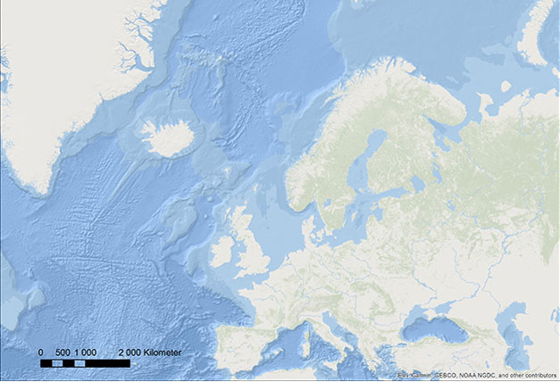
The map shows the relative water depths, by shading, of the North Atlantic, the North Sea and the Baltic Sea. The image shows the continental shelf as the lighter blue fields adjacent to land. The shelf ends at the continental slopes off the west coast of Norway, Great Britain, Ireland and France. Thus the whole of the Swedish seabed constitutes part of the continental shelf.
The continental shelf is also legally defined (not just geologically), inter alia under the 1982 Convention on the Law of the Sea. The Convention on the Law of the Sea is a global UN convention on how the countries of the world divide up the global ocean and its resources, i.e. the continental shelf and the seabed, but also the water column itself (the water mass).
Sweden has also implemented national legislation, the Act on the Continental Shelf, which implements both the earlier 1958 Convention on the Continental shelf and the 1982 Convention on the Law of the Sea. According to the Act, the continental shelf is defined as the seabed and its underlying base within public waters and in a specific area outside the sea territory (or territorial waters), the so-called economic zone. You can read more about territorial waters and public waters below.
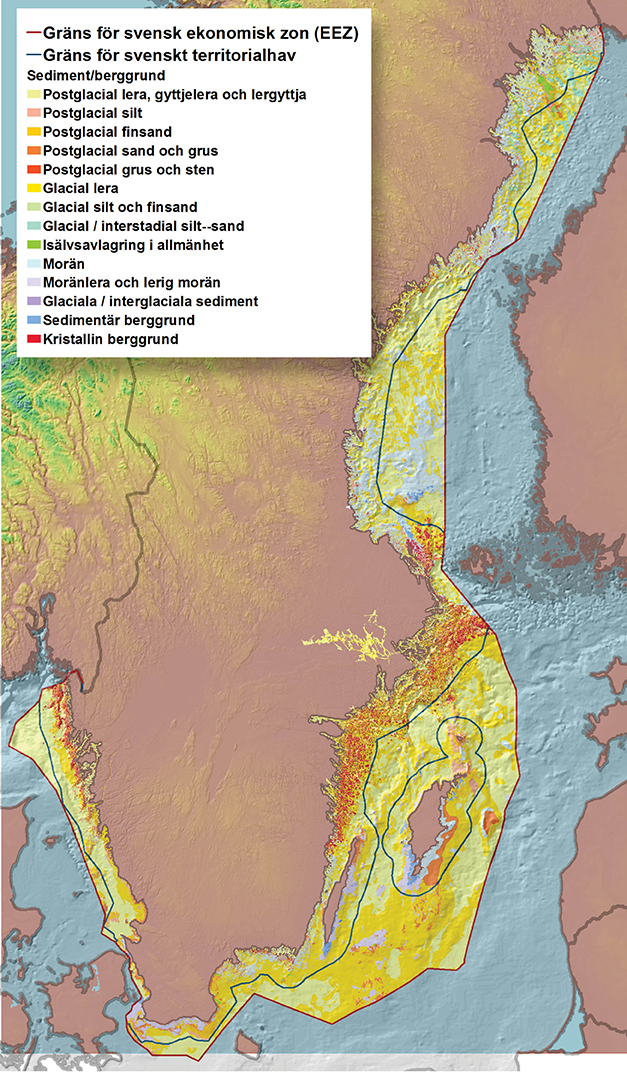
The map shows the legal limits of the Swedish continental shelf, the Swedish territorial sea and the Swedish economic zone, as well as the general composition of sediments and bedrock in the upper part of the seabed.
About the Swedish sea territory (territorial waters)
Sweden's sea territory includes the so-called internal waters and the so-called territorial sea.
Internal waters include those water areas inland and in the sea that lie within the national border and the so-called base lines. Baselines (normal and straight) are used under the Convention on the Law of the Sea to calculate the breadth of the territorial sea and are drawn between the baseline points identified by the coastal state along its own coast. In principle, the territorial sea extends 12 nautical miles beyond the area of the internal waters.
Water belonging to a land property is referred to as private water. Water that does not belong to a land property is referred to as public water. Public water is found in the sea, as well as in the lakes Vänern, Vättern, Hjälmaren and Storsjön. The other Swedish lakes consist solely of private waters (see the Swedish Public Water Areas (Boundaries) Act [1950:595]).
Why a permit is required
According to the Swedish Continental Shelf Act, only the Swedish state has the right to explore the continental shelf and to extract its natural resources. However, the Act also states that the government – or an authority appointed by the government – may issue a permit to parties other than the state to explore the continental shelf and to extract resources from it. The permit requirement applies only to parties other than the state. A government administrative body does not need a permit under the Continental Shelf Act.
Exploration of the continental shelf may include, geophysical measurements, measurement of the seabed from ships, and drilling or blasting. Such investigations may be necessary e.g. for the establishment of offshore wind power, demonstration facilities for wave power or for pipelines or underwater cables to be laid on the seabed.
Natural resources of the continental shelf include mineral and other non-living natural resources on, within or below the seabed. Examples of such resources are sand, gravel and rock. Usages include bridge construction, beach nourishment, wind power foundations etc.
No permit is required for the capture of living organisms. However, it should be noted that the Swedish Fishing Act (1993:787) regulates fishing activities, e.g. in Sweden's sea territory and within Sweden's economic zone.
It should also be noted that the terms of the Swedish Continental Shelf Act on exploration and extraction also apply to the laying of underwater cables and pipelines on the seabed, both in territorial waters and in the economic zone. The same applies to so-called carbon capture and storage (CCS).
Is it possible to obtain a permit for oil or gas operations?
No, the Swedish Continental Shelf Act explicitly prohibits this.
Permit period of validity
The Swedish Continental Shelf Act stipulates that a permit shall be granted for specified period of time. An exploration permit is normally limited to a period of validity of 3 - 5 years.
In relation to extraction permits the Proclamation (1966:315) concerning the Application of the Act on the Continental Shelf states that extraction permits granted by SGU may be valid for a maximum of 10 years. (see paragraph below "Applying for permits")
A permit must be conditional
A permit shall be subject to the conditions necessary to protect public interests and individual rights, such as protecting human health and the environment against damage and nuisance, promoting the long-term good management of land and water and other resources, and ensuring safety and security.
These conditions may for example include measures to prevent air or water pollution, protect wildlife, to preserve boreholes, mineral deposits or other resources, or to protect shipping or fishing.
The conditions may relate to how the works are managed and carried out, to the design of facilities on the continental shelf, or to the use of the products. The conditions may also relate to requirements for mapping documentation as well as sampling and reporting of the works and its activities.
Does a permit constitute an exclusive right to explore or extract resources within the area in question?
No, the permit does not give exclusive rights to the exploration or extraction of resources within the area in question. The exception is permits in relation to the exploration of the continental shelf for carbon capture and storage (CCS).
Consequently, the Swedish Continental Shelf Act does not contain any provisions governing exclusive rights in the same way as the Swedish Minerals Act does. However, Section 7 of the Swedish Continental Shelf Act states that, in the case of permits for extraction, work carried out under older permits must not be prevented by the rights established by a more recent permit. The work must therefore be organised in such a way that holders of the previous permit have priority to carry out their work efficiently and to the minimum detriment of the holder of the more recent permit.
It may also be mentioned that the exploration of the continental shelf or the extraction of its natural resources must not be carried out in such a way as to damage underwater pipelines or to improperly encroach on shipping, fisheries or marine biology resources. Holders of permits granted under the Swedish Continental Shelf Act also have to tolerate the laying or maintenance of cables or pipelines within the permit area, provided that the work is carried out without undue impediment to the activities of the permit holder. Permit holders also have to tolerate certain types of scientific research within the permit area (Section 6 of the Proclamation concerning the Application of the Act on the Continental Shelf).
Applying for a permit
An application for a permit to explore the continental shelf is usually handled by SGU. If the intended activities concern another state, are extensive in scale, or may cause significant harmful effects, or if the Swedish Environmental Protection Agency, the Swedish Agency for Marine and Water Management or the Swedish Armed Forces request it, SGU shall refer the case to the government for handling, together with SGU’s own opinion on the case.
Applications for permits to, for example, lay underwater cables and pipelines on the seabed, or construct offshore wind farms, are always handled by the government. Decisions on permits to extract natural resources from the continental shelf are also taken by the government. However, if a permit application is submitted for the extraction of sand, gravel or rock in marine public water areas, the application will be handled by SGU. If the extraction is on a larger scale, may have significant harmful effects, of if the Swedish Environmental Protection Agency or the Swedish Agency for Marine and Water Management request it, SGU shall refer the case to the government, accompanied by SGU’s own opinion on the case.
Exploration methods
General
Exploration (surveying) of the seabed (continental shelf) can be carried out in a variety of ways - for example, by seabed sampling and video filming, or by drilling, blasting, piling, cone pressure testing and so-called vibrocoring. Surveys can also be carried out by geophysical measurement, for example with magnetometers and gradiometers. Surveying can also be carried out by sound-generating measurement methods, i.e. with various types of hydro-acoustic measuring instruments, such as multi-beam sonar, side-scanning sonar, sediment sonar and seismic surveys.
Both vessel movements (by the survey vessel) and physical interventions in the seabed can generate sounds that may have negative consequences, especially for marine mammals like porpoises and seals. This applies to an even greater extent to sound-generating measurement methods, where instruments with certain lower frequencies – for example, seismics, sedimentation sonar (so-called SBP, sub-bottom profiles) or side-scanning sonar with low frequency sounds – cannot be used at all in certain areas and during certain periods and otherwise only on certain conditions. Examples of such permit conditions are the use of passive acoustic monitoring and so-called “soft” start-up of the surveying equipment. Other requirements may be the use of various scaring methods and providing a dedicated observer with marine biology competence on the survey vessel.
The planning and conducting of investigative surveys requires extensive and careful consideration. There are a number of companies on the market offering these services.
Specific information on investigations prior to the laying of an underwater cable or pipeline
An investigation prior to the laying of an underwater cable or pipeline should generally focus, amongst other things, on the mapping of sedimentation types to the relevant sediment depth. This is necessary, e.g. to determine where to take environmental samples and to establish which methods (e.g. flushing, ploughing, covering) are best suited for the laying of the cable or pipeline in the sediment to the required depth. Normally, surveys should initially be performed using appropriate hydro-acoustic measurement. The measurement data is then interpreted, e.g. in order to determine where accumulation beds are located. This enables environmental sampling to be undertaken at relevant locations in order to find potential environmental contaminants. To provide reliable results environmental sampling requires high precision and therefore needs to be carried out at suitable locations with appropriate equipment and by expert and experienced personnel.
Contents of the permit application
The Proclamation concerning the Application of the Act on the Continental Shelf sets out the main requirements regarding the contents of the permit application. However, the requirements differ depending on the type of application (for example, surveying of the seabed, sand extraction or the laying of underwater cables).
It is therefore always necessary to assess what an application should contain on a case-by-case basis:
- information on the applicant, address, etc.,
- information about the area and on the period for which the application is made,
- information on the activity, its purpose, and which vessel(s), platforms, methods, instruments and sampling equipment are being deployed,
- the necessary information to assess compliance with the General Rules of Consideration as laid down in Chapter 2 of the Swedish Environmental Code and to assess the potential impact of the activities on the biological and physical environment;
- information on hydrography, for example water depth, exposure to wave effects, currents, and stratification and properties of the water mass;
- information on geology, e.g. the properties and composition of the seabed, geotechnical conditions and the distribution of sediment, bedrock and surface substrates, as well as the structure of the seabed, properties, geotechnical conditions and composition (sediment layers) down to the relevant sediment depths below the seabed surface; in some cases also information on the existence of natural erosion protection in the form of coarse residuals, young mud-rich sediments and sulphur-bearing sediments, known as sulphide soils;
- information on sediment-dynamic conditions, such as the prevalence of erosion, transport or accumulation bottoms at the site, the prevalence of accumulation of fine-grained sediments with a high organic content, sand transport systems and fine-grained sediments beneath natural erosion protection on the erosion or transport bottom;
- an indication of environmental chemistry conditions and environmental loads, for example: the extent and levels of high concentrations of organic pollutants and metals, see Class 5 and higher levels according to the criteria of the Swedish Environmental Protection Agency; in particular with reference to young muddy clay and silt sediments;
- information on flora and fauna, for example: presence of number of species, number of individuals, vegetation, marine mammals, bird life, species of animal or plants which are threatened, rare or require consideration for any other reason;
- information on, amongst other things, sand, gravel and mineral resources, pollution situation in sediments and water, antiquities and ancient monuments, aberrant objects, wrecks, unexploded ordnance, etc. within the area in question,
- information on the measures the applicant considers necessary to prevent water pollution and encroachment of shipping, fisheries and other public and private interests;
- work program for the activities,
- information on the applicant's technical and economic status and available resources for the activities,
- map (prepared in accordance with SGU’s instructions for the individual case), positions (preferably in SWEREF 99 TM) and a description of the site in question,
- copy of/information about any necessary distribution permits (see paragraph below "Specific information on hydrographic surveying and distribution permits", and
- Environmental Impact Assessment (if required).
When is an Environmental Impact Assessment required?
If the application relates to exploration of the continental shelf involving blasting or drilling, or if the application is for the extraction of natural resources from the shelf, the applicant is normally required to draw up an Environmental Impact Assessment in accordance with the provisions established in Chapter 6 of the Environmental Code, if the activity or measure is likely to have significant environmental impacts.
Obtaining the required information
In the general planning of the investigation, construction or extraction, SGU's marine-geological products can be used. These include maps on various themes and to various scales and their accompanying descriptions. Other examples of SGU’s marine-geological information are maps and data from sediment sampling and seabed surveys.
SGU also holds results from analyses of a variety of heavy metals and organic compounds from sampling in marine areas where sediments accumulate, providing an indication of environmental conditions and environmental loads.
All of these data provide an overview of the properties of the seabed and sediments in different areas of the sea. The data are available in the SGU map viewers Marine geology, Marine geology metals and nutrients, Marine geology organic environmental toxins and Environmental monitoring, marine sediments. Descriptions are available at SGU Geolager. The databases can also be ordered through SGU customer services.
In order to obtain detailed information on the data that should be included in an application for extraction or the laying of pipes/cables, you may be required to conduct your own investigations (which may also be subject to licensing, see the above paragraph "Why a permit is required"). These may include surveys of seabed conditions (physical environment as well as biology) and sampling and analysis of the sediments at the site in question.
The studies can be carried out using e.g. hydroacoustic instruments such as multi-beam sonar, side-scan sonar or sedimentation sonar) and/or geophysical instruments such as magnetometers).
Handling of permit applications
Provisions on the handling of permit applications are laid down both in the Swedish Continental Shelf Act and in the Proclamation concerning the Application of the Act on the Continental Shelf. General procedural rules are also laid down in the Swedish Administrative Procedure Act (2017:900).
A permit application is generally handled as follows:
- The application and its annexes, as well as any Environmental Impact Assessment, are checked. If supplementary information or investigations are required, these are requested from the applicant.
- The application is referred to the relevant authorities, such as the Swedish Armed Forces, the Swedish Coast Guard, the Swedish Maritime Administration, the Swedish Environmental Protection Agency, the Swedish Agency for Marine and Water Management and the Swedish National Heritage Board. In addition, the matter is sent to the relevant County Administrative Board(s) and, in the case of wind power or gas pipelines, also to the Swedish Energy Agency and the Energy Markets Inspectorate.
- The applicant is given the opportunity to respond to the comments received.
- SGU collates the comments received and the applicant's response to them.
- SGU makes an assessment of the application. SGU's knowledge and experience of the geological conditions of the site and the possible environmental impact of marine activities are in many cases of crucial importance to the assessment.
- SGU makes a decision on the case. If the application must be handled by the government, SGU instead submits its assessment to the government with a decision-making proposal (including a proposal for terms and conditions).
Usual duration of the processing period
SGU's processing of an application under the Swedish Continental Shelf Act generally takes an average of approximately 6-12 months. If the application is handled on behalf of the government, the government's own time for processing the case is added to this. However, the duration of the proceedings may be shorter or longer depending on the circumstances of the individual case.
Sometimes a notification is sufficient
Sometimes it is sufficient to submit a notification to SGU instead of a permit application. This is the case for certain scientific surveys carried out by a Swedish scientific institution or other surveys carried out by a Swedish natural or legal person within the territorial boundary, and which does not include blasting, drilling or any other significant environmental intervention. Note that the notification obligation, just like the licensing obligation (see information under the heading "Why a permit is required" above), only applies to parties other than the Swedish state. A government administrative body is therefore not required to submit a notification.
The notification must be submitted in writing to SGU at least 14 days before the start of the works.
There is no explicit regulation determining what a notification should contain. However, it must contain the information necessary for SGU to be able to determine whether the activity is subject only to the notification obligation or if a permit must be applied for. In addition, the notification must specify the area to be surveyed and include sufficient information for SGU to assess any protective measures and precautions required by the applicant. SGU may ask the applicant to submit such information if it is not provided in the notification.
With regard to both the issue of notification or licensing obligations and the issue of any safeguards and precautions that may be necessary, there are a large number of factors that should be considered, such as:
- the duration of the investigation (the survey period),
- when the survey is going to take place (time of year),
- the size of the survey area (geographical extent, coordinates),
- the type of site (e.g. with regard to geological conditions or to whether the area is protected, such as Natura 2000 areas or other protected areas)
- the type of survey or survey method (for example, penetrating sonar, multi-beam sonar, side-scan sonar, video surveying, etc.),
- if bottom samples or sediment samples are to be taken in such a way (for example, with clamshell bucket, box corer or equivalent) or in such a quantity or volume that the sampling may have a significant impact on the seabed,
- the water depth at which the sediment is to be sampled and to which depth (within the sediment),
- whether so-called cumulative effects may arise, in particular as a result of any activities impacting the environment which are already being carried out within the area in question, and
- whether the investigation relates to a so-called UXO survey (survey of the seabed to detect unexploded ordinance).
About SGU's service obligation
SGU, like all government administrative bodies, has a specific service obligation to individuals (see Section 6 of the Swedish Administrative Procedure Act [2017:900]). However, this obligation does not extend to providing, for example, legal advice or assistance with producing an application, for example by giving various forms of prior notifications or assessments. In addition, SGU has to avoid competing with private operators and therefore may only carry out contract activities to a limited extent (see Section 10 of Ordinance [2008:1233] instructing the Geological Survey of Sweden). Prior notification etc, may also conflict with SGU's role as the assessing, decision-making and supervisory authority in relation to the Swedish continental shelf legislation.
Permits may be revoked
Licences may be revoked by the government or by SGU (if the permit has been granted by SGU) if the provisions or the terms and conditions have not been complied with. Revocation may also take place for so-called “exceptional reasons”, but in such cases the permit holder may be entitled to compensation.
SGU has the right to obtain geological results
SGU is entitled to observe the geological work of the permit holder and to obtain the geological results of the work (Section 9, Swedish Continental Shelf Act). Permits (and notification decisions) pursuant to the Swedish continental shelf legislation therefore normally include a condition stipulating that, upon completion of the investigations, a copy of all geological/geotechnical information collected from the Swedish continental shelf area, raw data as well as interpretations and summaries, must be submitted to SGU in a format approved by SGU.
A summary of formats approved by SGU is set out below. SGU also generally accepts formats equivalent to those listed below.
| Data type | Format | Comment | |
|---|---|---|---|
| Raw data | Profile data | SEG-Y, version 1.X | Sub bottom data |
| Side scan sonar data (HF/LF) | XTF | ||
| Data from Multi beam, Swath sonar, etc. | Instrument´s default format | Depth and backscatter data including all relevant sensor data | |
| Video | Optional common format | Incl. position file if available | |
| Photo | Optional common format | Incl. position file if available | |
| Sensor data | Optional common format | Incl. position file if available (e.g. CTD, SVP, oxygen and current) | |
| Magnetometer/gradiometer data | Optional common format | ||
| Overview maps | Line map/line maps | ESRI Shape and pdf | Position overview (Trackchart) for all measuring instruments/data types |
| Point map/point maps | ESRI Shape and pdf | Position overview (Pointchart) for all sample points/observation points/measurement points/photo points/video points/sensor points, etc. | |
| Processed data | Processed profile data | SEG-Y, version 1.X | Best available resolution and quality |
| Side scan sonar data (HF/LF) | Mosaic in GeoTIFF (floating point) | Best available resolution and quality | |
| Multi-beam data, swath data etc. | GSF | Cleared data | |
| Depth data (Multi-beam, Swath sonar, etc.) | GeoTIFF (floating point) and BAG | Best available resolution and quality | |
| Backscatter data (Multi-beam, etc.) | GeoTIFF (FLOATING POINT, dB) | Best available resolution and quality | |
|
Magnetometer data (Anomalies) |
GeoTIFF (floating point) |
Best available resolution and quality |
|
|
Interpreted/classified data |
Maps (geological, biological, etc.) |
ESRI Shape (incl. lyr file) and pdf |
Shape in the best available resolution and quality. PDF in scale and format that enables reviewing. |
|
Profiles (geological) |
|
In scale and format that enables viewing. |
|
|
Other data |
Observation descriptions and logs |
pdf or optional common format |
For example, descriptions from camera observations, sediment samples and CPT measurements. |
|
Analysis results |
pdf or optional common format |
E.g. Particle size analyses and environmental chemical analyses. |
|
|
Reports |
|
|
|
|
Summaries/collations |
|
|
|
|
Project description |
|
Text about project and data |
|
All data collated, processed or produced in connection with a permit (or notification) obtained under the Swedish continental shelf legislation must be delivered to SGU. All data must include coordinates.
SGU and the Swedish Coast Guard are responsible for supervision
SGU supervises compliance with the regulations and conditions governing permits under the Swedish Continental Shelf Act.
However, the Swedish Coast Guard is responsible for supervision in respect of the laying of underwater cables and pipelines on the continental shelf outside Swedish territorial waters.
It is a criminal offence not to comply with the provisions of the Swedish Continental Shelf Act
You can be sentenced to fines or imprisonment if, for example, you are carrying out explorations of the continental shelf without permission, or if you do not comply with a permit condition. However, in certain cases, special government decisions are required for prosecution purposes.
Here are the rules!
The rules on licensing obligations, etc., are primarily laid down in the Act (1966:314) on the Continental Shelf (Swedish Continental Shelf Act) and in the Proclamation (1966:315) concerning the Application of the Act on the Continental Shelf.
In addition, there are a large number of relevant provisions in other legislation, for example:
- The Environmental Code (including general rules of consideration, management provisions, environmental quality standards and provisions on Environmental Impact Assessments and Natura 2000 sites)
- Act (2017:1272) on the Swedish Territorial Waters and Maritime Zones
- Act (1992:1140) on Sweden’s Exclusive Economic Zone
- The Public Water Areas (Boundaries) Act (1950:595)
- Act (2016:319) on the Protection of Geographical Information (e.g. on hydrographic surveying and distribution permits)
- Act (1996:518) on Liability for Compensation for damage to underwater cables, pipelines, etc.
- Electricity Act (1997:857) (on network concessions, etc.)
- Act (1978:160) on Specific Pipelines
Specific information on hydrographic surveying and distribution permits
The Act (2016:319) on the Protection of Geographical Information establishes provisions for the protection of data relevant to the defence of Swedish territories. The Act contains provisions limiting the right to hydrographic surveying. According to the Act, "hydrographic surveying" means the permanent recording of geographical information in a specific water area or at a specific distance from a water area. As a general rule, no hydrographic surveys may be carried out in Swedish territorial waters, except in lakes, rivers and canals. Issues relating to permits for hydrographic surveying are handled by the Swedish Armed Forces.
The Act also contains provisions limiting the right of distribution of a compilation of geographical information. According to the Act, a compilation of geographical information refers to geographical information in the form of reproduction (mapping), description or measurement (survey). As a general rule, such dissemination is prohibited if the compilation refers to conditions in a specific water area or at a specific distance from a water area which relates to Swedish territorial waters, except lakes, rivers and canals. Issues concerning permits for the distribution of geographical information relating to Swedish territorial waters are handled by the Swedish Maritime Administration.
In our role as a licensing and supervisory authority in terms of the Swedish Continental Shelf Act, SGU has during a period of years noted that there are shortcomings in this legislation which risk impeding and delaying operations and projects beneficial to society. On 29 November 2022, SGU submitted a formal request to the government regarding desired changes to the legislation which would make it more adapted to present and future societal circumstances and requirements.
Last reviewed 2022-11-29