
Waste pile at the Sällberg mines, Skälö, ca. 20 km south of Västervik.
Mapping in northern Småland and Östergötland
The Geological Survey of Sweden (SGU) launched a mapping project in 2023 focused on northeastern Småland and southeastern Östergötland. The project is divided into three subareas: Skrikerum, initiated in 2023, Västervik, which started in 2024, and Åtvidaberg, scheduled to start in 2025 or 2026.
To general goal of the project is to upgrade SGU’s bedrock map database to a more detailed scale, as well as to sample and analyse the mineralisations in the area with a focus on so-called critical and strategic raw materials. Geological, geochemical, and geophysical data collected during the project are continuously made available in SGU’s databases. Below are brief descriptions for each subproject, including preliminary results.
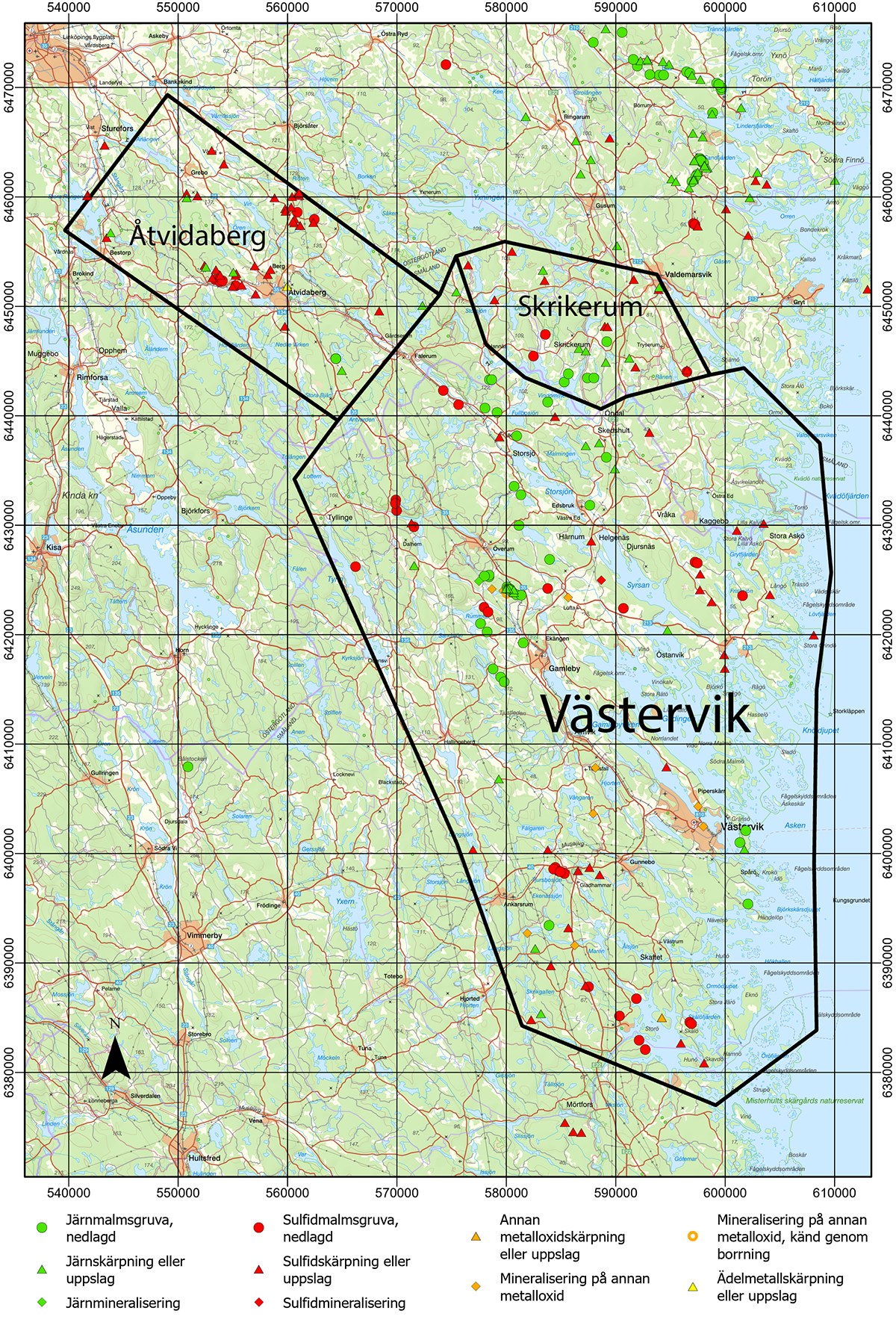
Map showing the three subproject areas, including known mineral resources and mineralisations. ”Other metal oxide” in this case mainly refers to uranium or rare earth elements occurrences. Basemap from Lantmäteriet, one grid square equals 10 x 10 km.
Subarea Skrikerum
In the Skrikerum subarea, previously known mineralisations of iron, copper, and selenium have now been reassessed with a focus on critical and strategic raw materials. Fieldwork started in 2023 and was concluded in 2024, yielding a total of 83 observations now included in SGU’s database Bedrock observations. A total of 35 samples were collected from outcrops and waste piles for lithogeochemical analysis. Additionally, petrophysical measurements were performed on 78 samples, providing data on the physical properties of the rock types, including density, magnetic susceptibility, and electrical conductivity.
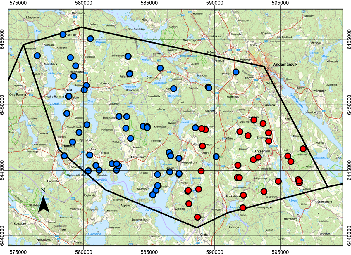
Map showing the subproject area Skrikerum. Observations made in 2023 are marked with red dots, and 2024 year’s observation marked with blue dots. Basemap from Lantmäteriet, one grid square represents 5 x 5 km.
Preliminary findings reveal anomalous concentrations of copper, gold, nickel, cobalt, selenium, tellurium, manganese, and rare earth elements in several of the sampled mineral occurrences. An ultramafic rock sampled near Larum and Kvarnvik shows high concentration of MgO (26.0%), anomalous levels of chromium (2,200 ppm) and nickel (1,040 ppm, predominantly in sulphides), as well as elevated boron concentrations. This mafic body also corresponds to the most prominent gravity anomaly in the Skrikerum subarea. Additionally, skarn with garnet and magnetite sampled from the Skårsjö minefield shows anomalous concentrations of rare earth elements (433 ppm REE+Y).
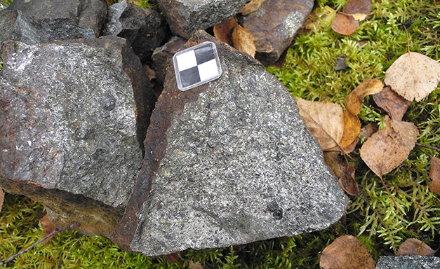
Waste rock from a copper-nickel-iron mineralisation east of Karlsmåla. Anomalous concentrations of copper (1.56%), cobalt (599 ppm), nickel (1,650 ppm), sulphur (14.5%), selenium (32.7 ppm), tellurium (3.96 ppm), elevated concentrations of gold (0.16 ppm), bismuth (1.21 ppm), palladium (0.063 ppm), rhenium (0.038 ppm) and thallium (1.59 ppm). The mineralisations consist of pyrrhotite, magnetite, chalcopyrite and other sulphide minerals, hosted in a metabasaltoid (6452503/591624). Photo: Dick Claeson, SGU.
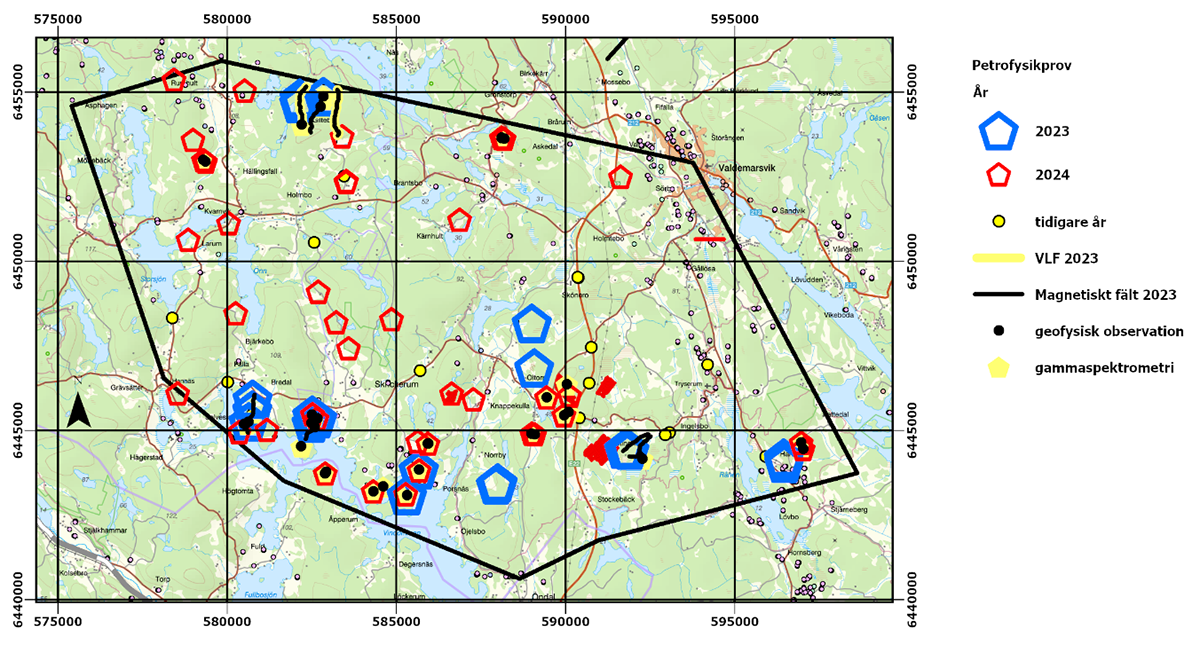
In 2024, geophysical measurements were carried out at 20 outcrops. Magnetic susceptibility was recorded for all rock types at all of these outcrops. Gammaspectroscopy measurements were conducted at 7 of these outcrops. Ground measurements (magnetometry) were performed along profiles at six localities, two of which are near historic mines, covering a combined profile length of ca. 24 km. New gravity measurements were also collected in the area during 2024. In addition, airborne geophysical surveys, including magnetic field, gammaspectroscopy and two-transmitter VLF, were conducted in 2023, with the resulting data released in 2024. These datasets will be integral as support for geological interpretations and modelling.
Map showing the subproject area Skrikerum with geophysical observations conducted 2023–2024. Basemap from Lantmäteriet, one grid square equals 5 x 5 km.
Further analysis and interpretations of the collected data are now underway, based on which revisions are made in SGU’s bedrock map database. The results will also be summarised and presented in an SGU report, scheduled for publication in fall 2025.
Subarea Västervik
The Västervik subproject includes known occurrences of critical raw materials, such as the rare earth element mineralisations at Olserum and the cobalt-rich sulphide ores at Gladhammar. However, most of the area’s mineralisations are yet to be sampled and analysed using modern methods. A key objective of this project is to understand the formation processes and timing of these mineralisations during the area’s almost two billion years long geological history. Such knowledge could provide valuable insights to guide future exploration in the area.
Map of subproject area Västervik. Bedrock observations made in 2024 (green) and 2025 (purple) are shown as marked circles. Base map from Lantmäteriet.
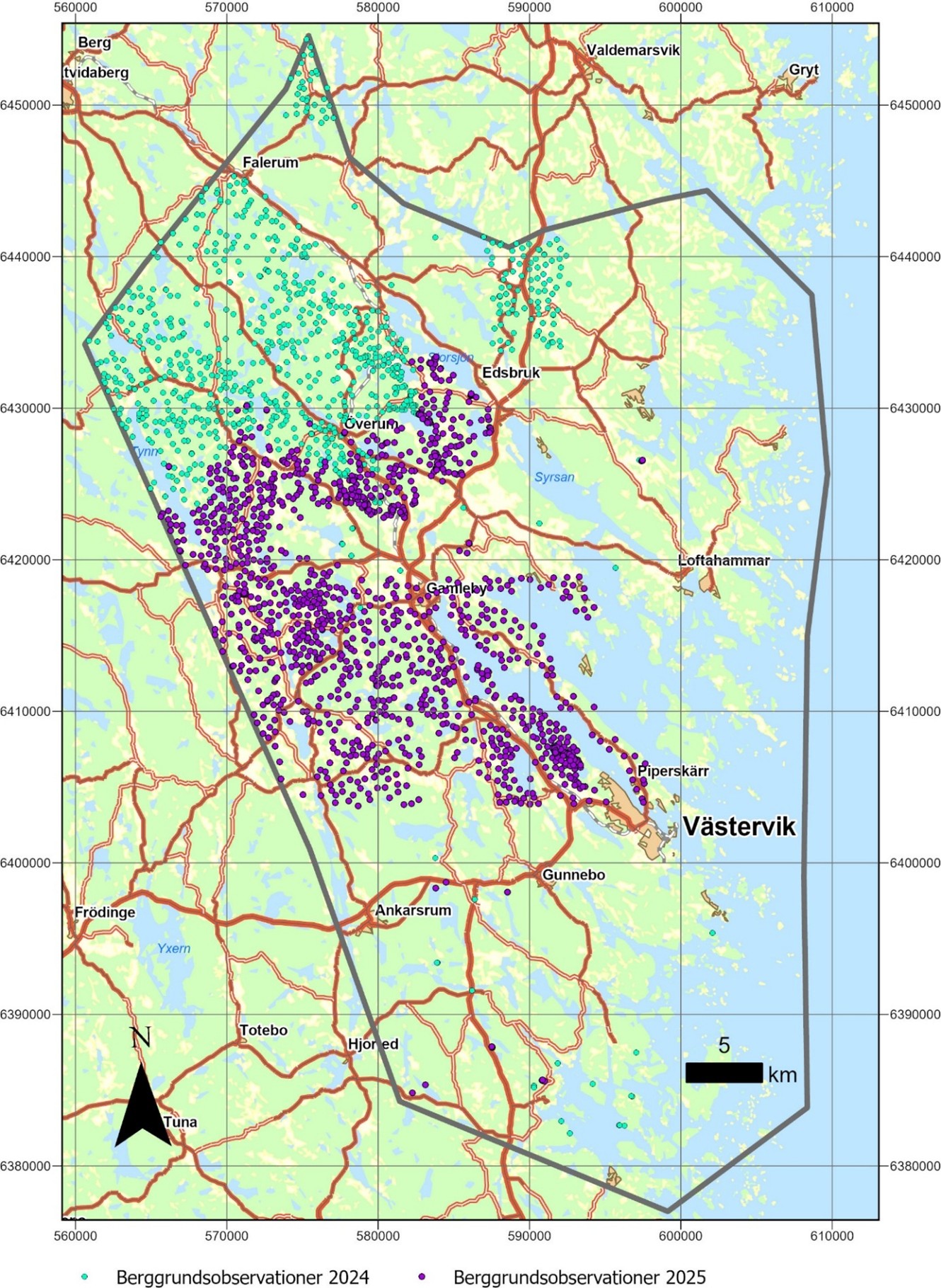
In the spring of 2024, initial sampling was conducted of most of the area’s known mineral occurrences. From June to September, bedrock mapping was performed in the northern parts of the project area (see map). A total of 839 locations were documented for rock types and other geological data, information which will be incorporated in SGU’s Bedrock observations database. Additionally, 74 samples were collected from outcrops and waste piles and sent for full geochemical characterisation. Five samples were taken for radiometric age determination.
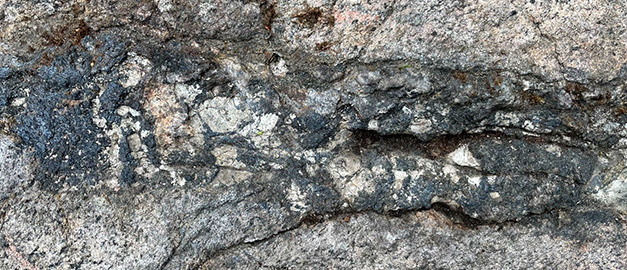
A vein of biotite, magnetite, fluorapatite and xenotime-(Y) in a strongly foliated granite. Olserum. Photo: Stefan Andersson.
The geochemical analytical results from the 2024 sampling of known mineral occurrences show elevated, and in some cases notably high concentrations of among others (maximum values): rare earth elements (14.5%), phosphate (7.98%), thorium (4.15%), copper (4.09%), titanium (2.73%), manganese (0.63%), uranium (0.40%), zirconium (0.31%), lead (0.18%), vanadium (708 ppm), tungsten (627 ppm), chromium (755 ppm), cobalt (373 ppm), bismuth (237 ppm), and gold (0.47 ppm). All these results are available in SGU’s Lithogeochemistry database.
In 2025, a selection of samples collected in 2024 were examined in greater detail through thin-section studies and microprobe analysis. The latter was performed using an energy-dispersive X-ray spectrometer (EDS) for imaging and semi-quantitative mineral chemical analyses. The objective was to identify which minerals host various critical metals, such as rare earth elements (REE), within the sampled mineral occurrences.
The results confirm that the REE phosphates monazite and xenotime, similar to those in previously known mineralisations in the Olserum area, are also the primary carriers of rare earth elements in the mineralisation at Flaken, approximately 6 km northeast of Överum. In other investigated mineralisations, such as those at Trostad and Melsjön (around 6 km northeast and 9 km north of Gamleby, respectively), rare earth elements occur in more complex titanium-bearing minerals such as davidite, as well as minerals from the aeschynite mineral group, and in secondary bastnäsite.
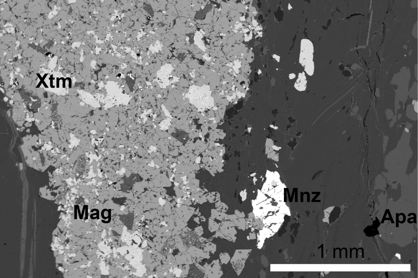
BSE image (back-scattered electron) showing the presence of co-existing fluorapatite (Apa), monazite (Mnz), xenotime (Xtm), and magnetite (Mag) in an Olserum-type rare earth element mineralisation. Sample WLW240014A from the Flaken mineralisation at Bildstena, approximately 6 km northeast of Överum. Photo: Stefan Andersson.
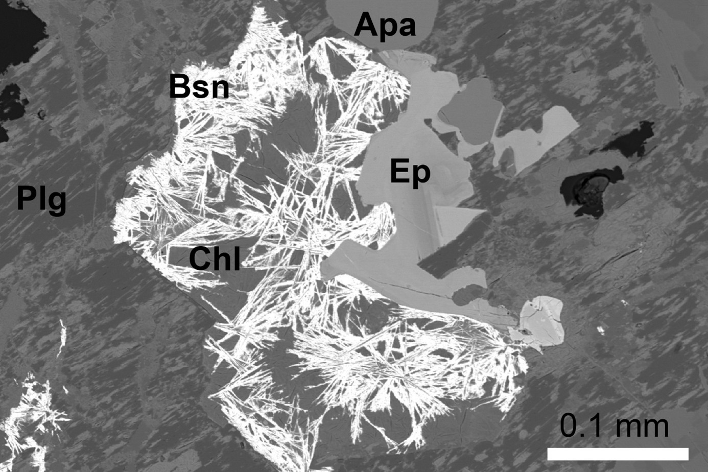
BSE image (back-scattered electron) showing the occurrence of secondary bastnäsite (Bsn) in a rare earth element mineralisation. Sample SAN240044A from the Melsjön mineralisation, approximately 9 km north of Gamleby. Other mineral abbreviations: Apa – fluorapatite, Plg – plagioclase, Chl – chlorite, Ep – epidote. Photo: Stefan Andersson.
Fieldwork continued in 2025 with additional surface mapping and continued sampling of the area’s mineral occurrences. Between May and September, geological information was recorded at a total of 1,302 sites. The investigations have led to several new and noteworthy discoveries, including rare earth element mineralisations.
The identification of several smaller but previously unknown occurrences with rare earth element mineralisation of the so-called Olserum type, located as far as 10 km northwest of the previously known Olserum mineralisation, demonstrates that this type has a wider regional distribution than previously assumed. This indicates that the Västervik area holds significant potential for further discoveries of occurrences with critical and strategic metals.
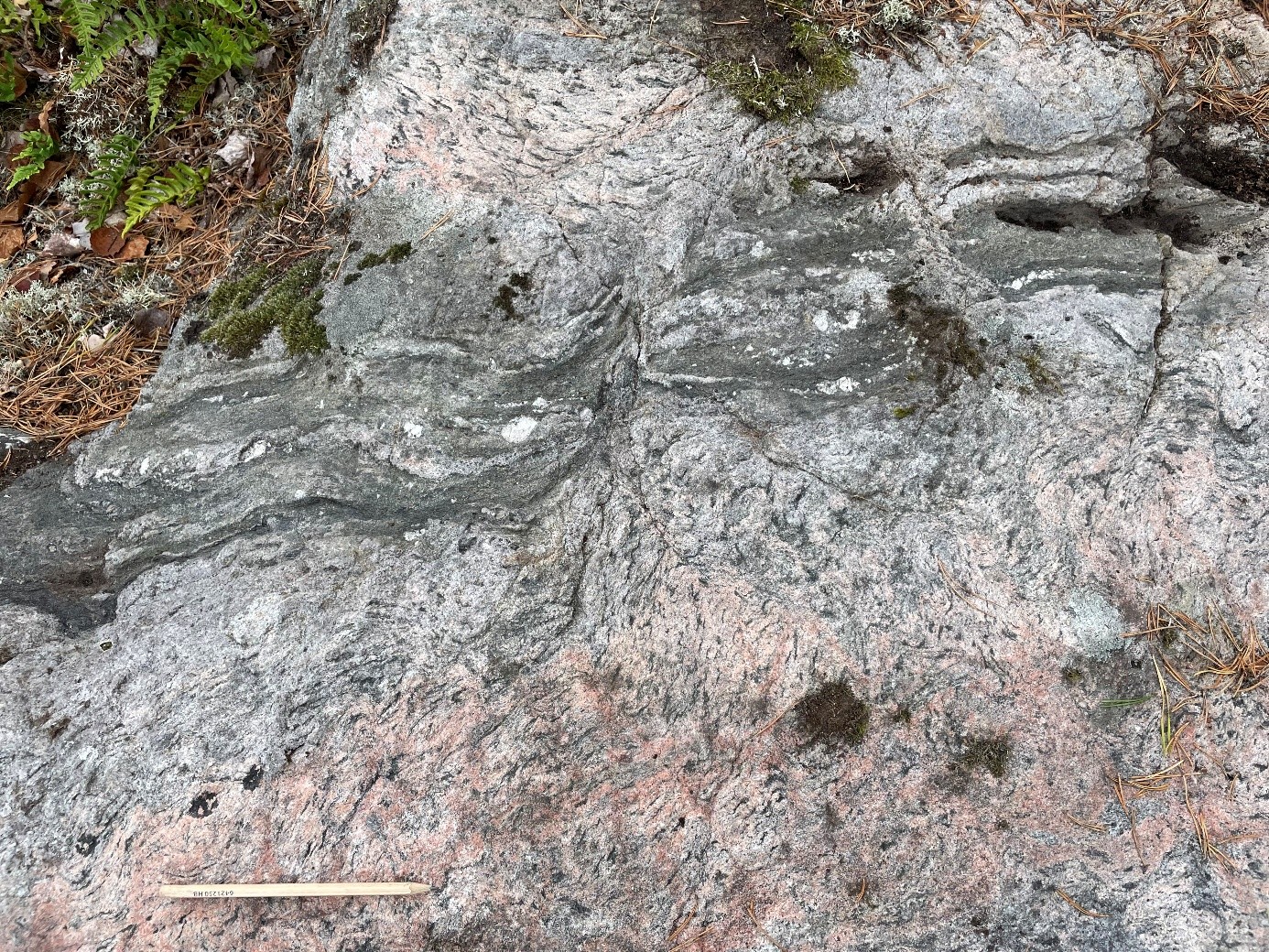
A vein of biotite and fluorapatite of Olserum-type within a strongly deformed and altered granite from a newly discovered mineralisation from Olstorp in 2025.
Photo: Stefan Andersson
A total of 78 samples were collected and sent for geochemical characterisation, and 16 samples collected for petrophysical measurements. Five samples were collected for radiometric dating.
The geochemical analytical results from 2025 from various mineral occurrences show elevated, and in some cases high, concentrations of, among others (maximum values in parentheses): phosphate (2.57%), copper (2.4%), rare earth elements (1.1%), bismuth (>1%), lead (9330 ppm), tungsten (5250 ppm), cobalt (1300 ppm), chromium (895 ppm), tin (892 ppm), zinc (738 ppm), vanadium (537 ppm), nickel (476 ppm), thorium (402 ppm), molybdenum (330 ppm), uranium (233 ppm), tellurium (38 ppm), gold (1.7 ppm), palladium (0.084 ppm) and platinum (0.078 ppm). In addition, new representative samples from the mineralisation at Öbälen confirm the elevated concentrations of rare earth elements analysed during 2024. Several other mineral occurrences that had not previously been sampled also show elevated levels of these elements, including the smaller copper mineralisation near Lake Ommen. All these results are made available in SGU’s Lithogeochemistry database.
Geophysical surveys
The collection of new geophysical data by aircraft was carried out across the entire area in 2023. The data include magnetic field measurements and gamma spectrometric measurements, presented as concentrations of potassium, uranium, and thorium in the ground, as well as so-called two-way VLF measurements, which provide information on the electrical conductivity of the subsurface. The geophysical fieldwork, consisting of observations and measurements, is based on this updated dataset to further investigate and interpret the properties and distribution of different rock types.
In 2024, the focus was on the northwestern part of the Västervik subarea. A total of 50 outcrops were visited for sampling and gamma spectrometric measurements on outcrop. Another 77 samples were collected for petrophysical measurements (density, magnetic susceptibility and electrical conductivity).
In 2025, the work continued southward, covering the same subarea as the ongoing geological mapping. During 2025, 172 samples were collected for petrophysical analysis, and 130 gamma spectrometric measurements were carried out on outcrop. In three areas, ground-based magnetic field measurements were conducted to further investigate anomalies observed in the airborne magnetic data, two areas with the aim of better delineating bedrock units, and one area to examine an anomaly associated with mineralisation.
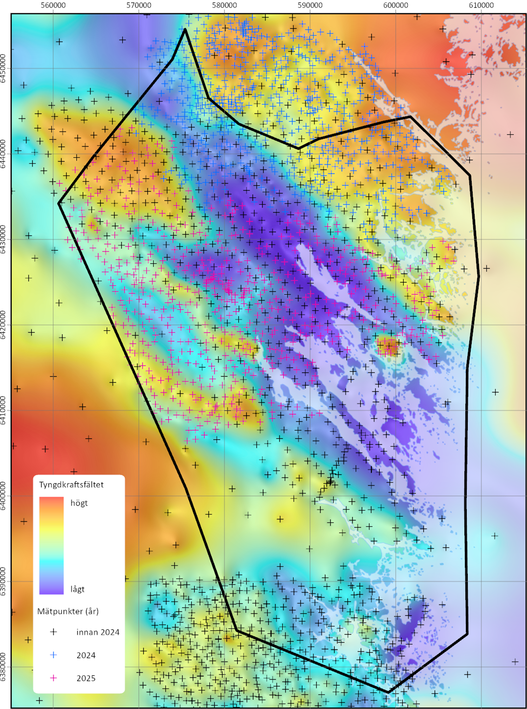
In 2024 and 2025, new gravity measurements were also carried out within the subarea, and this work will continue in the coming years. With these new measurements, the number of data points within the subarea has more than doubled (1,602 points up to and including 2025), resulting in clearer and, in some cases, new anomalies in the gravity data.
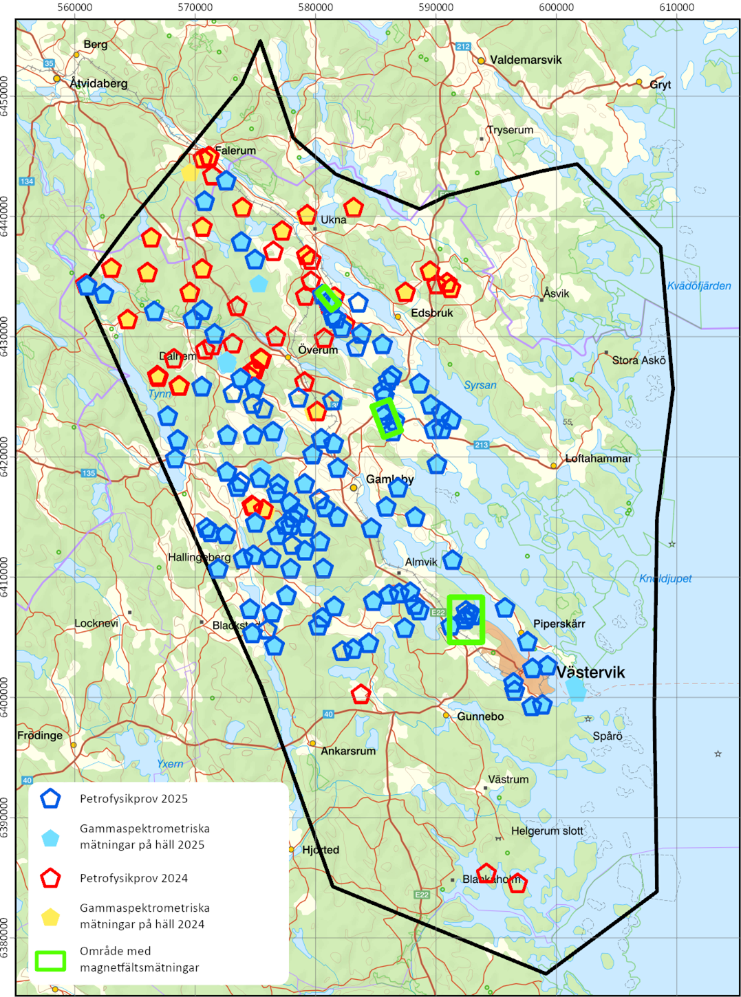
Map of geophysical observations conducted in 2024 and 2025 in the Västervik subarea. Pentagons indicate petrophysical sampling locations, and filled pentagons indicate sites where gamma spectrometric measurements on outcrop have been carried out. Base map from Lantmäteriet, one grid square equals 10 x 10 km.
Map of the gravity field in the Västervik subarea. A significant densification of measurement points was carried out in 2024 and 2025. Measurements will continue in 2026. One grid square equals 10 x 10 km
Delområde Åtvidaberg
Around Åtvidaberg, known copper mineralisations exists. However, these have largely not been sampled and analysed using modern methods that target a wide range of metals and elements. In some cases, rare earth elements have been detected in association with iron mineralisations, but it remains unclear to what extent the critical or strategic raw materials are present in the area. The primary focus of this subproject will be to investigate the area’s mineralisations and conduct bedrock mapping of the surrounding area. The work is currently scheduled to begin in 2025 or 2026.
Last reviewed 2025-01-08